
Discover the Snowies Alpine Walk: A 4-Day, 55 KM High Country Adventure

If you’re craving a remote, high-altitude escape through Australia’s stunning alpine wilderness, the Snowies Alpine Trail promises an unforgettable hike.
This Grade 3 and 4 hike spans 55 kilometres over 4 days through the best of Kosciuszko National Park. From sweeping mountain vistas to serene alpine meadows, the Snowies Alpine Trail is a true showcase of the High Country’s raw beauty—ideal for those seeking both solitude and adventure.

Whether you’re planning your next backcountry expedition or a 1 day hike instead this guide will help you prepare for every step of this alpine journey.
With the final section of the trail only completed in November 2024, this new addition to Australia’s hiking scene is set to become a favourite for outdoor lovers and alpine adventurers alike.
You can experience the Snowies Alpine Walk in a way that suits your pace and style — whether over three or four days, or by completing each section individually as day hikes.
There’s no right or wrong way to do it. The flexibility of this trail makes it perfect for both seasoned trekkers and casual adventurers.
There are also many companies where hikers are picked up at the end of each day and returned to nearby accommodation within Kosciuszko National Park — ideal for those who want to enjoy the alpine scenery without camping.
The NSW national parks website has more information if you chose to do it this way.
But if you prefer to camp along the way and save on accommodation, this itinerary offers the best low-cost option for completing the Snowies Alpine Walk.
At various points along the Snowies Alpine Walk, the trail follows sections of other established tracks, which may be signposted under different names — these have been seamlessly incorporated into the broader Alpine Walk route.
Day 1: Guthega to Charlotte Pass – A Scenic Start to the Snowies Alpine Walk

The Snowies Alpine Walk kicks off with a stunning introduction to the Australian high country, as Day 1 takes you from Guthega to Charlotte Pass.
At just 9 km, this is the shortest leg of the multi-day hike, but it’s packed with beautiful scenery. The trail closely follows the Snowy River for certain sections of the walk.
Hikers are treated to expansive alpine meadows in bloom during summer, offering meadows of wildflowers and sweeping views that set the tone for the days ahead.
At the start, at Guthega the walk is also called the Illawong walk until it turns into the Snowies alpine walk.
One of the highlights of this section is walking through the bush of snow gums, their twisted trunks and beautiful multi-coloured bark adding a magical feel to the trail.

There is only a small amount of elevation on this day with the trail mostly flat, except for a few small hills. The trail is clearly marked as it is mostly made of paved stones, or metal board walk for this section.
The best place to camp for the night is set near the river crossing, at a junction where three routes meet — the path to Charlotte Pass, the Main Range Walk and the Snowies Alpine that you would have just walked.
There is a large flat meadow, perfect to pitch a tent, relax, refuel, and soak in the serenity of the mountains. Whether you’re an experienced hiker or a first-time alpine explorer, Day 1 of the Snowies Alpine Walk promises a memorable start to this epic journey through the heart of the Snowy Mountains.

Day 2: Charlotte Pass to Mt Kosciusko Return
Day 2 of the Snowies Alpine Walk is all about reaching the summit of Mt Kosciuszko, Australia’s highest peak.
This 22 km return hike from Charlotte Pass offers incredible alpine scenery, high mountain ridgelines, and one of the most iconic walking experiences in Kosciuszko National Park.
Whether you’re camping or doing this as a day hike, there are two main route options to suit your preference.

Route Option 1: Main Range Walk to the Summit, Return via Summit Walk
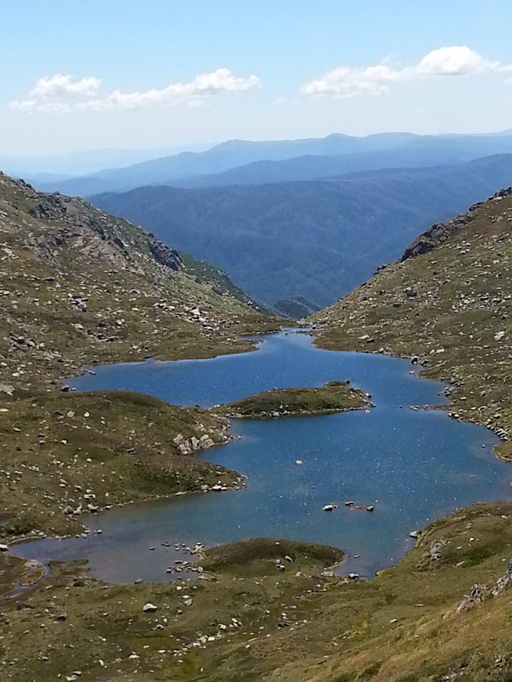
This option is the original and official part of the Snowies alpine walk — starting from Charlotte Pass, follow the Main Range Walk, which winds past the spectacular glacial Blue Lake and climbs high above it, offering panoramic views of the alpine wilderness.
The trail continues uphill toward the summit of Mt Kosciuszko, rewarding you with 360-degree views from Australia’s highest point.
From the summit, descend via the Summit Walk (Kosciusko Road), which is a more direct, gently graded path leading back to Charlotte Pass. This loop combines dramatic landscapes with a steady climb and an easier return route.

Route Option 2: Summit Walk to the Peak, Return via Main Range Track
If you’d prefer an easier ascent, start the day by heading up the Summit Walk (Kosciuszko road) from the Charlotte Pass car park — a gradual, more direct route to the summit of Mt Kosciuszko.
After taking in the views, descend via the Main Range Track, enjoying a more relaxed downhill walk past Blue Lake and back toward your riverside camp or Charlotte Pass.
Route Option 3: Summit Walk to the Peak, Return via Summit Walk
Lastly if you’re looking for the fastest and easiest route, the most direct option is to take the Summit Walk (Kosciuszko Road) from the Charlotte Pass car park straight to the summit of Mt Kosciuszko, and return via the same trail.
This well-formed track offers a steady incline with wide, accessible paths, making it a popular choice for hikers wanting to reach Australia’s highest peak without tackling steeper alpine ridge lines.
While it may be the quickest way to the top, this route still delivers breathtaking views of the surrounding Snowy Mountains, making it a rewarding experience for walkers of all levels.
Day 3: Charlotte Pass to Perisher Valley

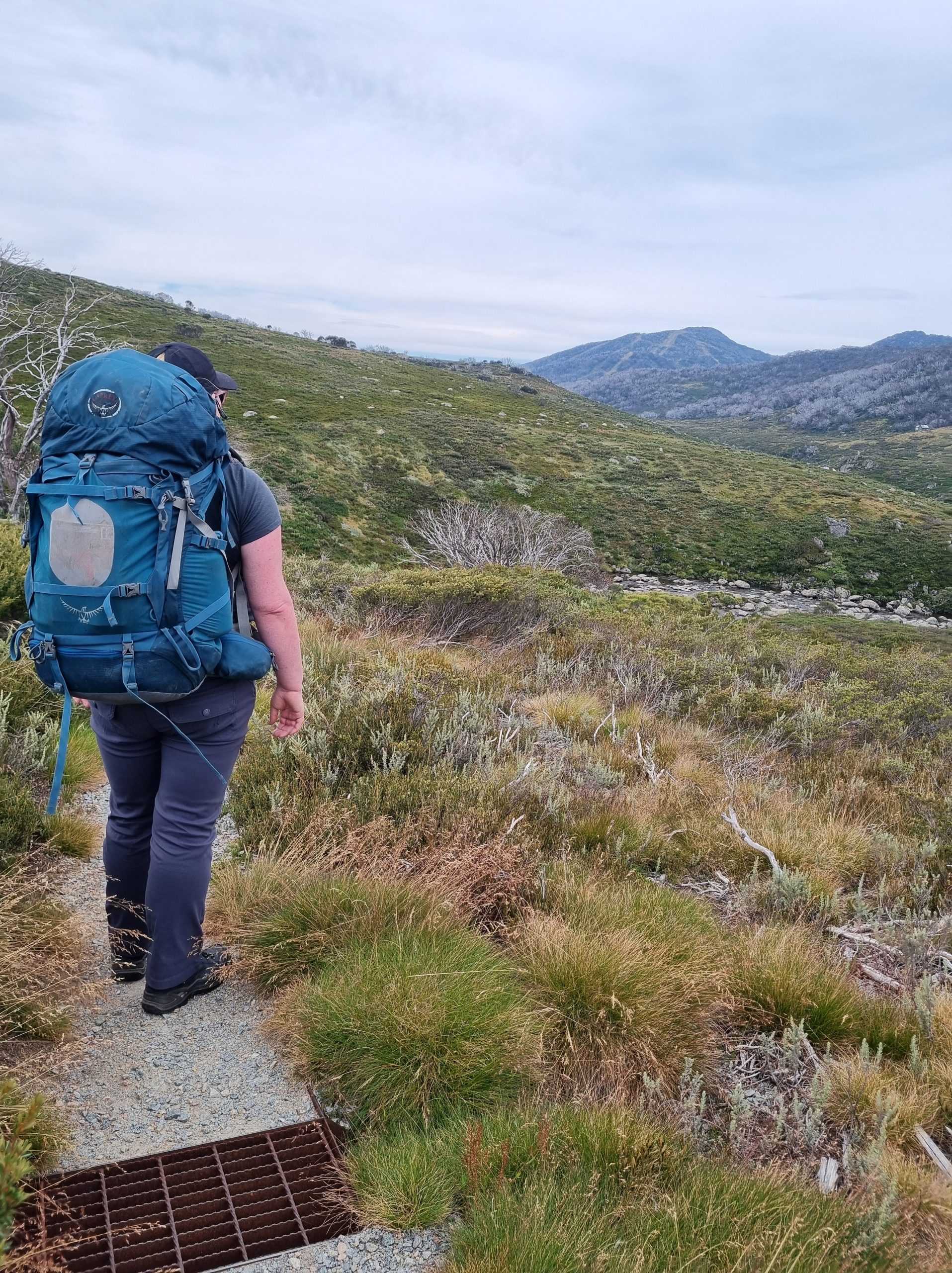
Day 3 of the Snowies Alpine Walk takes you from Charlotte Pass to Perisher Valley, covering approximately 12.7 km through some of the most open and exposed alpine terrain of the walk.
While the elevation profile looks mostly flat, don’t be fooled — this section includes plenty of ups and downs, particularly after the halfway point.

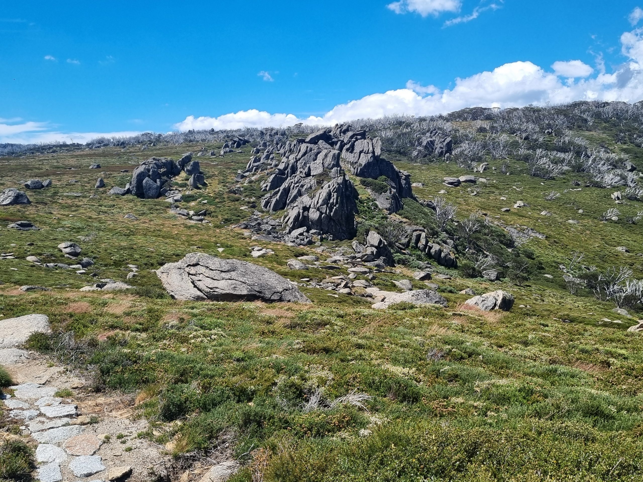
The trail begins with a couple of kilometres through the tree line, offering brief shade before opening up to wide alpine plains with lots of large granite slabs and ridge-top views.
Most of this stretch follows the Rams Head Range, and is a combination of dirt trail, paved stones and metal boardwalk.
Near the top of Porcupine Rocks, the trail transitions into the Porcupine Rocks Walk, which winds its way down into Perisher Valley, where you can finish the day down in the valley by the river.
One important thing to note: This section is very exposed, with minimal shade and limited water sources.
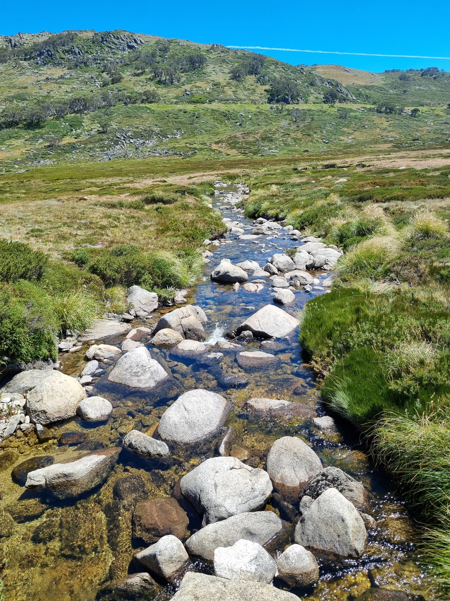
Aside from a creek crossing near the start and another around the 5 km mark, there are no other reliable water points along the way. When we walked this section, the temperature unexpectedly soared to 27°C — nearly 10 degrees above the forecast — and even though I had 4 litres of water with me, it wasn’t quite enough and both my sister (who I was doing the walk with) and I ran out of water.
If you’re hiking in warmer months, make sure you carry plenty of water and take advantage of the creek and river to fill up your water supply.
Despite the unforeseen heat, Day 3 offers a unique contrast to the previous stages of the Snowies Alpine Walk, with its wide-open landscapes, big skies, and a rewarding finish with a dip in the river at Perisher.
Day 4: Perisher Valley to Bullocks Flat

Day 4 of the Snowies Alpine Walk marks the final section of this incredible alpine walk, taking you from Perisher Valley to Bullocks Flat over a scenic 12 km stretch.
This newly completed section of the trail — officially opened in November 2024 — offers a fitting and rewarding end to the journey through Kosciuszko National Park.
The day begins with a brisk uphill climb for the first kilometre or so, leading you up to the ridge line. Once you’re up on the ridge, expect strong alpine winds — this exposed section can be blustery, so an extra layer might come in handy.
After descending off the ridge, the trail becomes more sheltered as you start heading downhill weaving through the trees.

The terrain on this section is varied, made up of metal boardwalks, paved stone paths, and natural dirt trails. In terms of difficulty, I found this was the second easiest day of the Snowies Alpine Walk, after Day 1.
The walk concludes at the Bullocks Flat Ski tube car park, a convenient endpoint with transport access and a sense of completion as you descend back into the lower alpine landscape.
With panoramic views, mixed terrain, and that satisfying end-of-hike feeling, Day 4 of the Snowies Alpine Walk is a beautiful finale to one of Australia’s newest multi-day treks.
Additional Essential Information
Before setting out on the Snowies Alpine Walk, it’s important to be well-prepared — this hike is in an alpine area, and conditions can change rapidly, even in the summer months. Here are a few key things to keep in mind:
- Maps & Navigation: You can download the full trail map on the AllTrails app for offline use, or pick up a paper map from the Kosciuszko National Park Visitor Centre in Jindabyne. Having both is a smart move, especially as some areas have limited or no phone signal.
- Rapid Weather Changes: The Snowy Mountains are known for unpredictable alpine weather, including the chance of snow even in summer. Always check the forecast and pack layers, including a waterproof jacket and warm gear — just in case.
- Wildlife Awareness: This region is home to many snakes, especially in warmer months. Stick to the trail, wear long pants where possible, and watch where you step or sit. I had the unfortunate luck of coming across about 8 snakes over 3 days.
- Safety & First Aid: make sure you have a basic first aid kit, including snake bandages, blister care, emergency blanket and anything specific to your needs. It’s a remote area in parts, and being prepared makes all the difference.
- Stick to the Path: To protect the fragile alpine environment — and for your own safety — always stay on marked trails.

Frequently Asked Questions
How to get to the Snowies Alpine Walk?
If you don’t have anyone who can drop you off or pick you up, there are 2 options that run from the Jindabyne town centre that can get you up to the national park and back.
Where to find water
There are many Alpine creeks and the Snowy and Thredbo river that run in all different sections of this walk.
Always make sure you are using running water and that you use either water purification tablets, a life straw or boiling the water before consumption.
How hard is the Snowies Alpine walk?
The Snowies Alpine Walk is divided into four distinct sections, each offering a unique blend of landscapes and terrain — from alpine meadows and glacial lakes to rugged ridgelines and open plains.
Officially graded as a Grade 4 hike, this trail is best suited to those with moderate to high fitness levels.
Some sections are long and demanding, featuring summit climbs, steep ascents, and technical descents.
Whether you’re tackling it over four days or breaking it into shorter segments, the Snowies Alpine Walk promises a rewarding challenge through some of Australia’s most spectacular high country.
Can you free camp on the Snowies Alpine walk?
You can free camp in Kosciuszko national park and most places along the Snowies Alpine walk. There are a few exceptions including:
- You must camp a minimum of 30 metres away from a water source, such as a river or creek.
- You can not camp anywhere around the glacial lakes such as blue lake, club lake or Lake Albina.
- As this is a alpine area you need to pack out any waste you have including (emoji of poop) there are bins in Charlottes pass, Perisher and at Bullocks flat that you can use to dispose of waste.
- For further information see the the National parks website.
Where to Stay on the Snowies Alpine Walk?
If camping isn’t your thing, don’t worry — there are plenty of lodges, chalets, and hotels throughout the Kosciuszko National Park region that cater to hikers during the summer months.
Many of these accommodations are located in or near Perisher valley, Thredbo, and Charlotte Pass, offering easy access to the trail and comfortable amenities at the end of a big day on the track.
For a full list of available stays, seasonal openings, and bookings, visit the official Snowy Mountains tourism website.